
Tempo Traveller from Leh Ladakh to Manali
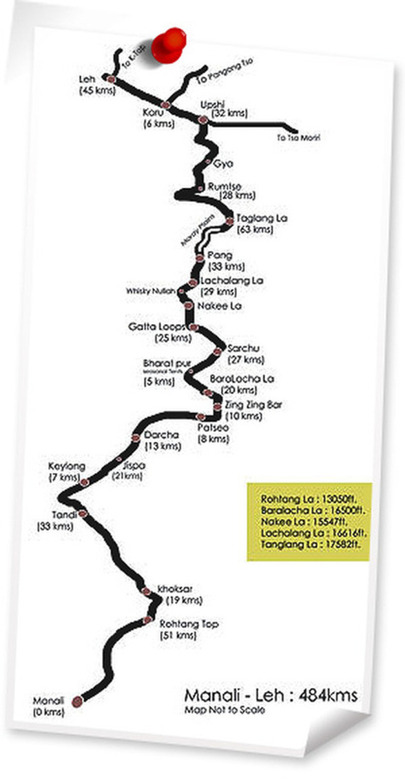
The Manali Leh Highway is open to vehicular traffic for only four and half months between June and mid-September, when snow is cleared from the road by the Border Roads Organisation. The highway connects the Manali valley to Kullu valley, Lahaul and Spiti and Ladakh. The highway crisscrosses some of the highest mountain passes in the world, including Rohtang La 3,978 m (13,051 ft), Baralacha La 4,892 m (16,050 ft), Lachulung La 5,059 m (16,598 ft) and Taglang La 5,325 m (17,470 ft). The latter two passes are less problematic over former due to less snowfall in Ladakh. Between Lachlung La and Taglang La this road crosses the Muri plains. A tunnel is being constructed to bypass Rohtang pass to make the highway an all-weather road. For almost half of its length, it is over 13,000 feet. The route passes through five high altitude passes. The terrain is so high and so barren as to have no settled habitation. Infrastructural support is at a bare minimum.
As the journey along the road normally takes two days (or more depending on road conditions), many tourists and travelers make overnight stops at Jispa and tented camps such as Sarchu. Alternately, overnight stops can be made at Keylong. Distance between Manali and Sarchu is 222 km (138 miles) in Himachal Pradesh state and distance from Sarchu to Leh is 257 km (160 miles), with total highway length of 479 km (298 miles). Owing to the high altitudes and the low-oxygen air, many travelers experience mountain sickness or in some cases even acute mountain sickness.
Manali-Leh drive should be done at a leisurely speed. Your first ever ride on this stretch will be the best; no matter how many times you ride on this road thereafter, you cannot beat your first experience on this route. Once in Manali, make sure you rest for at least a day to acclimatize to high altitude. Manali is a popular hill station so in the summers it is filled with weekenders and tourists from all over the world. It's better to start early in the morning to avoid tourist traffic. The Manali-Leh highway is a roller-coaster ride of high-altitude passes, bad roads, landslides, glacial melts, broken bridges and what not. So don't mistake it for 475 kms on a normal highway and a single day's ride. Manali-Leh drive should be done in two or three days. One also has to deal with Acute Mountain Sickness (AMS).
As soon as one leaves Manali, the climb for Rohtang Pass starts. After 52 kms of continuous ascent you reach Rohtang Pass. After Rohtang, the road descends into Chandra Valley passing through Khoksar and then to Tandi, where the Chandra river meets the river Bhaga.
Jispa, Keylong or Darcha, all are approximately 35 kms from each other after Tandi. Jispa has a hotel. Keylong, the only major town on Manali-Leh Highway has less luxurious but concrete hotels and guest houses. Darcha is a temporary tented accommodation where one gets a chance to interact with locals, listen to the Bhaga river flow, experience the chilling cold and perform morning duties out in the open.
Many visitors stretch the first day's journey up to Sarchu which is another tented accommodation and 120 kms further from Darcha. It depends on how many days you have at your disposal. Halt at Sarchu, just 120 kms into the ride from Darcha. But the small distance is a pure bliss of bad roads, streams, freezing temperatures, breathtaking landscapes and of course, headache from AMS.
To reach Sarchu, one has to cross Baralacha-La pass at 16,500 feet. Baralacha-La is the place where most travellers encounter symptoms of AMS, usually accompanied by headache, nausea, dizziness and vomiting. One also has to deal with innumerable streams running with freezing cold water from snow capped mountains.
The road before Sarchu is also the worst patch on Manali-Leh highway on any given year and also with maximum streams flowing untamed on the road.
After descending from Baralacha-La (actually the whole Manali-Leh Ride is riding up and down from one pass to another) you will get a small tented accommodation at Bharatpur and subsequently at Sarchu, where you have high profile tents with attach toilets to very basic tents put up by locals.
The best ride on Manali-Leh is also after Sarchu. After Sarchu, the state of Jammu and Kashmir starts and soon the Gata Loops happen - a succession of 21 hair pin bends lifting you 1,500 feet higher. And soon after, the Lachlung-La and Naki-la passes follow before one reaches Pang.
The road after Pang rises onto the More Plains, 42 kms of well tarred road, which is a welcome relief. After More Plains the climb for Tanglang-La, the second highest motor able pass at 17,582 feet starts. This is also the last pass on Manali-Leh highway. After the Tanglang-La descent, small villages, green fields and "JULLEY!" - a greeting in the Ladakhi language will add life to the relative straight road to Leh. Leh can be comfortably reached at a leisurely pace from Sarchu in a day.